A self-guided (independent) walking tour on the Dingle Way.
The Dingle Way independent walking tour is a circular walk from the colourful town of Tralee to the fishing port of Dingle and Slea Head, through one of the last strongholds of the Gaelic language and spectacular scenery, Dingle Peninsula (Corca Dhuibhne) an area rich in archaeological remains. Along the way we pass mountains, corrie lakes and beaches – the setting of many films, including ‘Ryan’s Daughter’ and ‘Far and Away’.
The average walking time ranges from 5 to 6.5 hours per day, at a leisurely pace.
11-day Tour Itinerary
Day 1 – Arrival
Optional Go Visit Ireland transfer from Kerry or Shannon Airport (see below) to Tralee.
Day 2 – Tralee to Camp
Distance: 18km/11.25miles Ascent: 275m/900ft
The first day’s walking is along the lower slopes of the Slieve Mish Mountains, with views over Tralee Bay, past early Christian ruins and pagan sites to the village of Camp. Overnight in Camp.
Day 3 – Camp to Annascaul
Distance: 17km/10.5miles Ascent: 350m/1,150ft
Today you cross the spine of the Dingle Peninsula to traverse above the wildlife sanctuary of Inch beach and then on green road and hilltop to the picturesque village of Annascaul, where you overnight.
Day 4 – Annascaul to Dingle
Distance: 21km/13miles Ascent: 410m/1,350ft
Continue along a medieval road to the fishing village of Dingle which is steeped in Irish culture and music and where the locals still speak in the native (Gaelic) tongue. Overnight in Dingle.
Day 5 – Free Day in Dingle
– Optional walks around Dingle (notes provided)
– Visit the Dingle Aquarium
– Boat trip to see ‘Fungi’, Dingle’s resident dolphin.
– Visit some of Dingle’s 52 pubs, craft shops, tea houses, book shops and famous restaurants.
– Boat trip to the Blasket Islands
– Relax in a local spa
Day 6 – Dingle to Dunquin
Distance: 19.5km/12.25miles Ascent: 345m/1,150ft
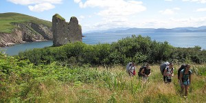
This days walking is spectacular, taking you via Ventry Beach and along the slopes of Mount Eagle to Slea Head. This stretch is famous for its concentration of archaeological sites. Overnight in Slea Head.
Day 7 – Dunquin- Cuas
Distance: 24km/15 miles Ascent 70m/230ft
This leg of the Dingle way takes us north along the Atlantic Cliffs, passing Coumenoole Beach, location for one of the dramatic scenes of the film Ryan’s Daughter and via the first of the beaches of Smerwick Harbour to Cuas village.
Day 8 – Cuas to Cloghane
Distance 18km/11 miles. Ascent 825m/2,700 ft.
This is an exciting day’s walk, which takes you high on the line of a military road to a saddle on the Brandon Mountain Range, then down enjoying spectacular views, to the shore of Brandon Bay. Good visibility – or navigating ability – is required.
Day 9 – Cloghane to Castlegregory
Distance 25km/15.5 miles. Ascent 85m/280ft.
To-day’s walk is substantially a beach walk, along the splendid strands of the northern side of the Dingle Peninsula. Road stretches intersperse, maintaining, “contact with civilisation.”
Day 10 – Castlegregory to Tralee
Distance 26km/16.25miles. Ascent 220m/725ft.
Today’s walk takes you back to Tralee, along the northern coast of the Dingle Peninsula, once again partly on beach, with the last stretch along the slopes of the Slieve Mish Mountains.
Day 11 – Departure
Departure after your full Irish breakfast.