The Kerry Way was founded by our director of activity programmes, Seán Ó Súilleabháin, over 25 years ago and is one of Ireland’s premier walking routes.
Seán was author of the best seller – Walk Guide – Southwest of Ireland. This is the ideal way to explore the Ring of Kerry. You start and end the tour in Killarney and on route you have a wonderful selection of woodland, valley and coastal walks. It will take 11 days to complete the Ring. The average walking time ranges from 5 to 7 hours per day at a leisurely pace. The Kerry Way 7 night (KW7) itinerary can be combined with the self guided ‘Dingle Way’ (DW7) to make a wonderful 14 night independent walking holiday.
Day 1 – Arrival in Killarney
Optional Go Visit Ireland transfer from Kerry or Shannon Airport Killarney.
Day 2 – Killarney to Black Valley
Distance: 20.5km/13miles Ascent: 350m/1,150ft
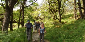
Walk through Killarney National Park passing the ruins of Muckross Friary, Muckross House and its gardens, up beside Torc Waterfall and along The Old Kenmare Road to the ancient oak woods beside the Killarney’s Upper Lake.
Day 3 – Black Valley to Glencar
Distance: 21km/13miles Ascent: 575m/1,900ft
Today, you walk through the rugged and lonely ice carved glens of Mid Kerry
(Black Valley and Bridia Valley) to overnight in storied Glencar.
Day 4 – Glencar to Glenbeigh
Distance: 17km/10.5 miles Ascent: 350m/1150ft
You walk from Glencar, with magical views of Caragh Lake, to the village of Glenbeigh,
with its sandy beaches. Overnight: Glenbeigh.
Day 5 – Rest/Option Day in Glenbeigh
Options: Choice of local walks (notes provided).
Adventure sports (canoeing, windsurfing, orienteering, etc.) at Cappanalea Outdoor Education Centre
Day 6 – Glenbeigh to Foilmore
Distance: 13km/8 miles Ascent: 320m/1,000ft
To-day’s walk takes you on the first coastal stretch of the Kerry Way, on the line of
a middle-ages coaching road, with spectacular views over Dingle Bay.
KW7 – Day 7 Foilmore to Caherciveen
Distance: 10km/6 miles Ascent: 90m/300ft
A short walk, perhaps a morning one, completes the journey along the northern side of Iveragh Peninsula to the coastal, and ancient, settlement of Cahersiveen, from which transfer for final night in Killarney.
KW11 – Day 7 Foilmore to Waterville
Distance: 20km/12.5 miles
To-day’s journey is mainly inland, on ridge-backs giving views of land and sea, finishing at the angling centre of Waterville on the shore of Ballinskelligs Bay.
KW11 – Day 8 Waterville to Caherdaniel
Distance: 12 km/8miles Ascent: 270m/900ft
Today you travel from one seaside village to the next, connecting Waterville to Caheraniel – this section of the Kerry Way is on a middle ages coaching road and offers wonderful views of bay, sea, islands and archaeological sites. Overnight in Caherdaniel.
KW11 – Day 9 Caherdaniel to Sneem
Distance: 17km/10.5 miles Ascent: 350m/1,150ft
This leg of the way provides walking mainly on the old coach road between the two settlements, in use for droving cattle up to the 1930s. You pass through the peat beds and close to the famous 2,000-year-old Staigue Fort. Overnight in Sneem.
KW11 – Day 10 Sneem to Kenmare
Distance: 32km/20miles Ascent: 520m/1,700ft
This is an attractive stage through woodland sections and close to the shoreline of Kenmare Bay. There are splendid views along the way. Overnight in Kenmare.
KW11 – Day 11 Kenmare to Killarney
Distance: 22.5km/14miles Ascent: 560m/1,850ft
The last leg of the Kerry Way takes us from the sea via mountain and lake through oakwood back to the Killarney National Park.
KW11 – Day 12 Departure
Note: Depending on accommodation availability we may offer the Kerry Way in reverse: Killarney – Kenmare- Sneem – Caherdaniel – Waterville – Caherciveen – Kells – Glenbeigh – Glencar – Blackvalley – Killarney.